CivicReport
Resident Reporting & Issue Management
Make municipal issue reporting simpler for everyone.
Give residents an easy way to report local concerns while providing municipal departments with the tools to review, organize, and manage incoming issues.
- No resident account required
- Works in any phone browser
- Staff dashboard included
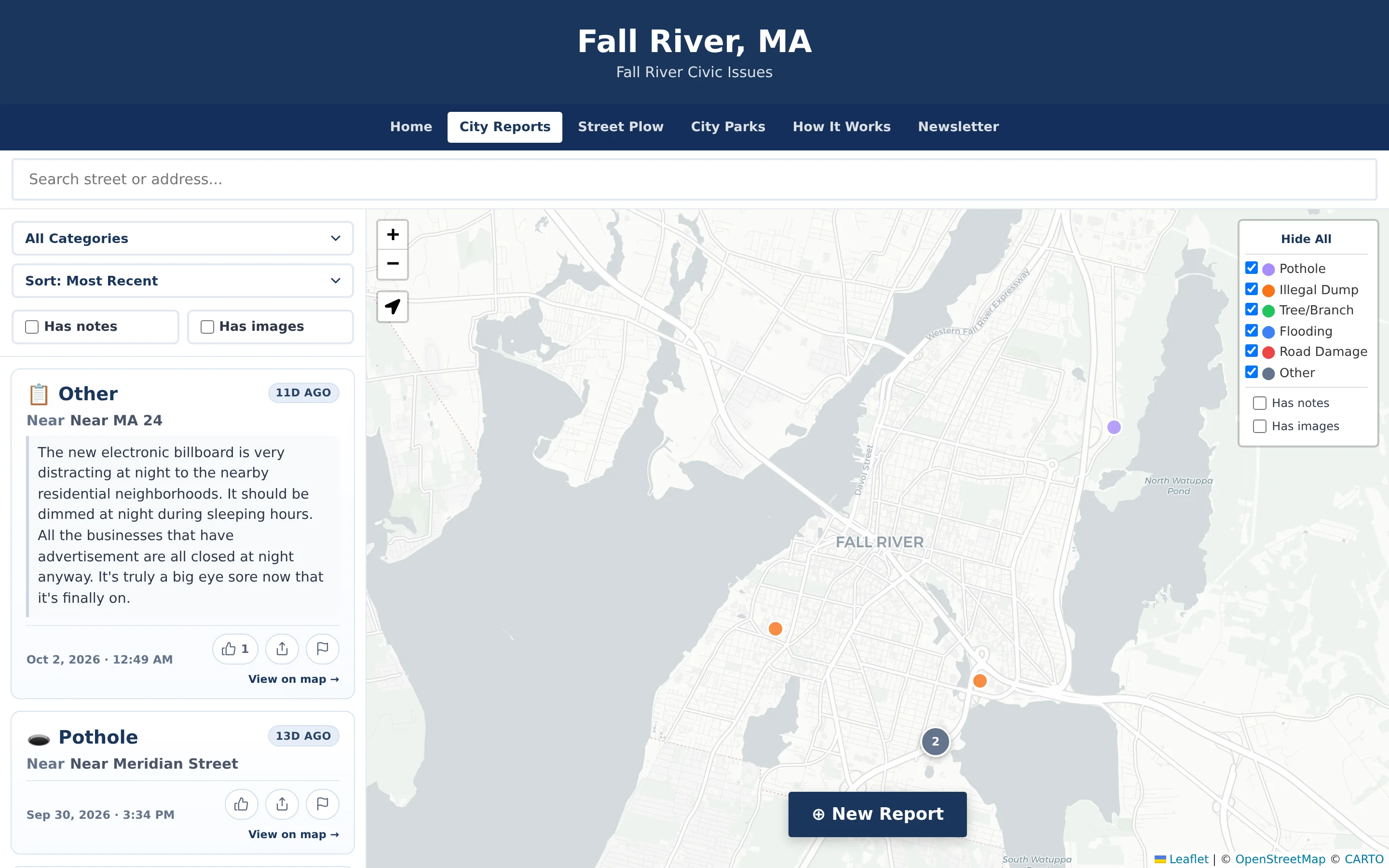
Resident concerns arrive everywhere except where staff can act on them.
In most smaller municipalities, a pothole or illegal dumping complaint might come in as a phone call to the clerk, a post in a community Facebook group, an email to a councilor, or a note at a public meeting. Nobody sees the full picture, the same issue gets reported five different ways, and residents rarely know whether anyone received it.
Scattered intake
Phone calls, emails, and social posts each land with a different person and leave no shared record.
Missing location detail
“The big pothole near the school” is hard to dispatch. Staff spend time just figuring out where an issue is.
No feedback loop
Residents report the same problem repeatedly because they cannot see that it was already received or resolved.
From a resident’s phone to a verified resolution.
CivicReport connects the public reporting experience to the staff tools behind it, so every report has a clear path.
- Step 1
Resident submits a report
Choose a category, place a pin on the map, and optionally add a short description or photo. No account or app download needed.
- Step 2
Dashboard receives it
The report appears in the municipal administration dashboard alongside every other incoming issue, with its location and details.
- Step 3
Department is notified
Reports are routed by category to the responsible department, which receives an email notification.
- Step 4
Staff track and verify
Staff review content, update status, mark issues fixed, and verify resolution so the public record stays accurate.
Everything needed to run non-emergency reporting.
A deliberately focused feature set: easy for residents, practical for staff, and configured around your departments.
Anonymous resident reporting
Residents report without creating an account or sharing their name or email address.
Interactive issue maps
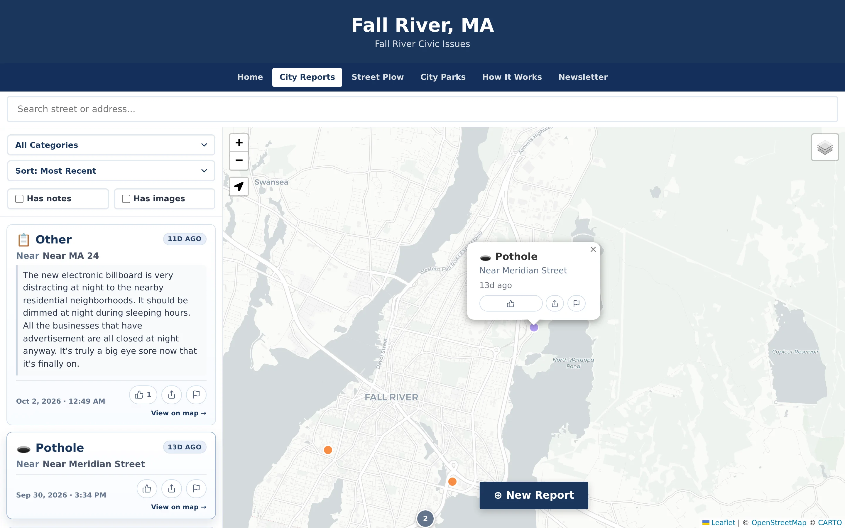
A public map shows reported issues with category filters, sorting, and clustering.
Report categories
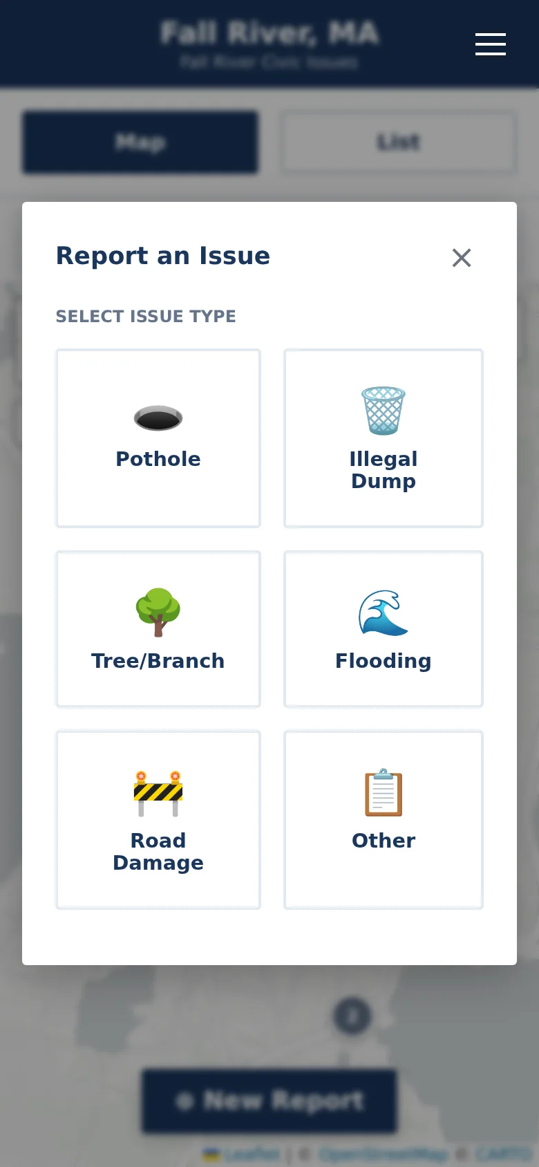
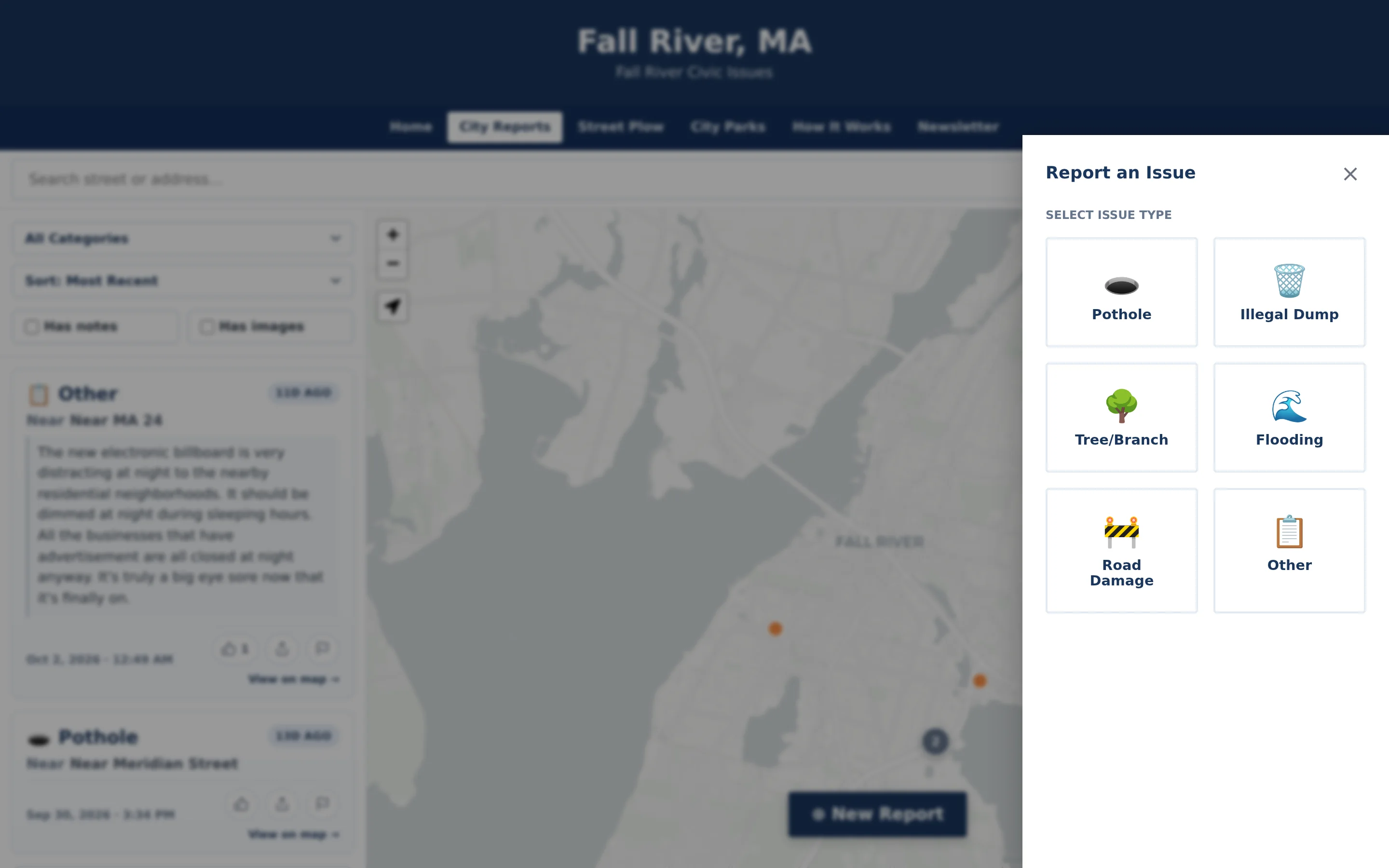
Clear categories such as potholes, illegal dumping, flooding, and road damage, configured for your community.
Precise locations & descriptions
Pin placement, address search, and optional notes remove guesswork about what and where.
Photo attachments
Residents can attach a photo from their camera or library; images are resized automatically.
Administration dashboard
One place for staff to review incoming reports, moderate content, and manage issues.
Department routing & email
Reports route automatically to the right department, with email notifications to designated staff.
Status tracking & verification
Track issues through resolution and mark verified outcomes that residents can trust.
See CivicReport in detail.
A reporting flow anyone can finish in under a minute.
Residents tap New Report, choose a category, pan the map to place a pin, and add an optional note of up to 280 characters or a photo. It runs in any modern phone browser — there is nothing to download and no account to create.
- Six clear default categories, configurable per community
- Address search and “use my location” for accurate pins
- Optional photo and note; automatic content screening before publication
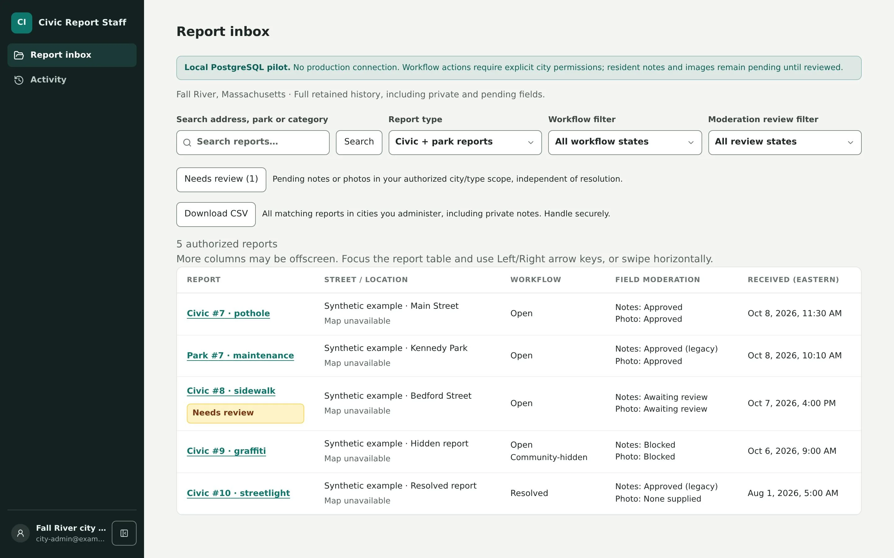
An administration dashboard built for day-to-day operations.
The dashboard is the operational heart of CivicReport. Staff review reports waiting for moderation, approve notes and photos, hide or remove inappropriate content, mark issues fixed, verify outcomes, post public announcements, and export records to CSV for reporting.
- Review queues for pending, blocked, hidden, and fixed reports
- Approve resident notes and images before they appear publicly
- CSV export for meetings, grant reports, and after-action reviews
The right report reaches the right desk.
During setup, each report category is mapped to the department responsible for it. When a resident submits a pothole, Public Works is notified by email; illegal dumping can go to Code Enforcement or the Board of Health. Departments act on the reports that belong to them without sorting through everything else.
- Category-to-department routing configured during implementation
- Email notifications to designated department contacts
- One shared record, regardless of which department responds
Verified status residents can tell apart from reports.
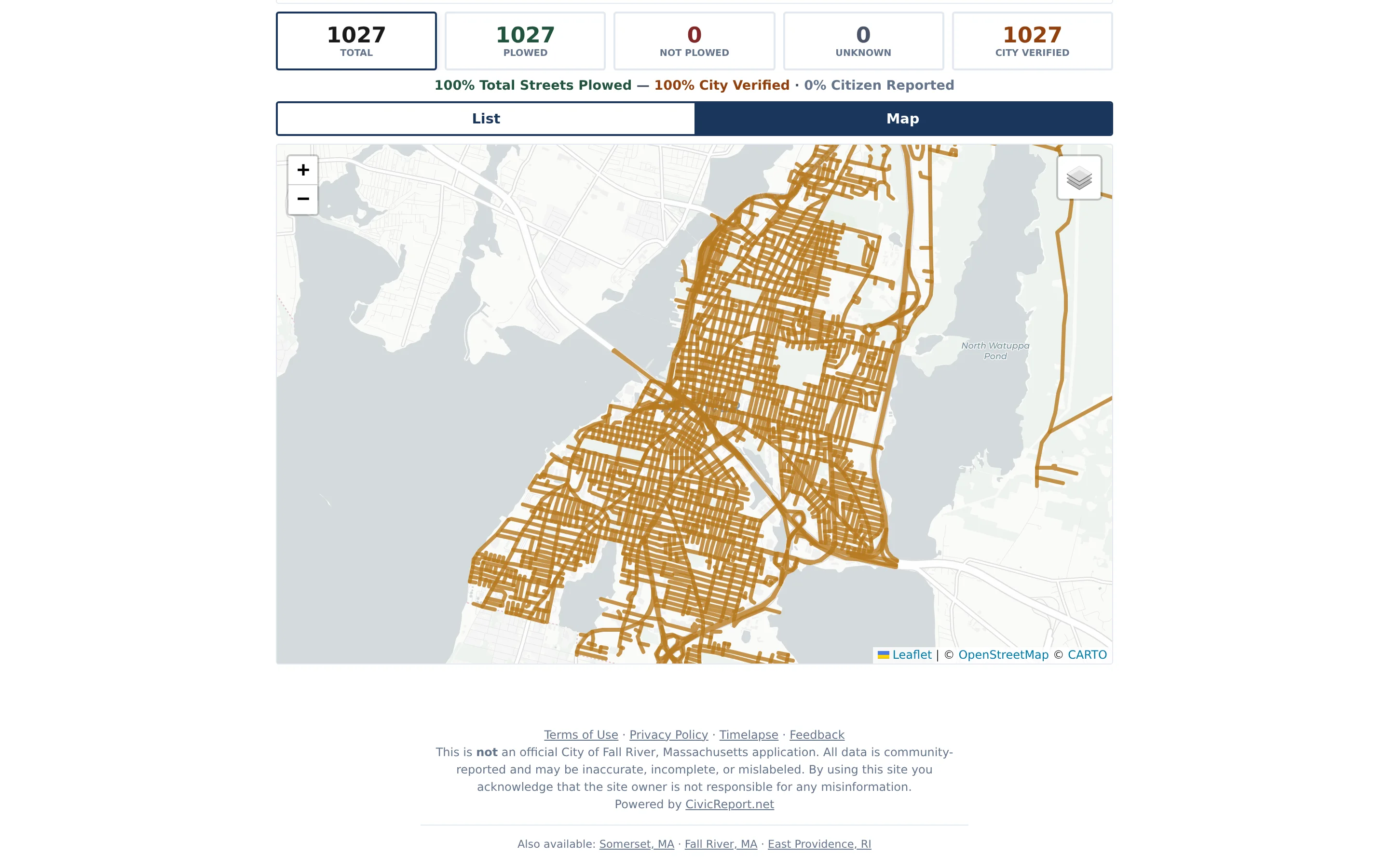
CivicReport separates what residents report from what the municipality confirms. In street-status mode, authorized staff can mark streets “City Verified,” which appears as a distinct gold badge on the public map. Residents see both perspectives without confusion.
- Distinct visual treatment for staff-verified status
- Resident confirmations and flags on each public report
- Timelapse playback for storm and event reviews
Storm street-status reporting, narrated.
CivicReport began with a practical question during the blizzard of 2026: how can residents and public teams see changing street conditions without relying on scattered calls and social posts? This narrated recording walks through the street-status workflow from that period.
About this recording: Recorded March 1, 2026, from an earlier “Plowed?” community experience. Branding, categories, and tools may differ from current deployments. References to municipal use, “City Verified” administration, and operational outcomes are the narrator’s statements and are not independently verified here.
Read the video transcript
Transcript note: The text below records the narration for accessibility. Statements about municipal use, “City Verified” administration, deployments, and operational outcomes are the narrator’s statements in the March 2026 recording and are not independently verified by this page.
Hey, it’s Matt from CivicTally. I wanted to show you our latest product, which allows towns and cities to have a crowdsourced live map service for their citizens, especially during snow removal. And especially when we had the blizzard of 2026, which really stalled the cleanup process in my hometown of Fall River, Massachusetts, I built this app to allow citizens to share the status of their streets so that we could see it on a live map.
This particular instance is actually looking at East Providence, which is also using the product. And if we zoom in, we can see streets that are labeled green for plowed and streets that are red for not plowed. Now, remember, this is crowdsourced information. A citizen goes to search for their street, finds their street on the list, or just simply types it in and starts searching for it. And then they label their street “plowed” or “not plowed.” They can vote once an hour. So if the status changes, they can come back and adjust their vote.
This allows the municipality and emergency services to have a bird’s-eye view on an interactive map that you can zoom in on and see where these reports are coming in, and a top-streets view so that you can drill down by the hour to see which streets are still being voted on the highest.
In terms of what I helped build out in Fall River was a City Verified feature. So we can build a custom dashboard for police, emergency services, and administration to come into the app and label streets City Verified if they’ve been cleared to the status that the city verifies is completely clear. So you’d have an admin dashboard to come in, punch in the streets that are City Verified, or download a list of streets with the votes and the rankings on them so that you can create a punch list to give out to staff or boots on the ground who are going through and double-checking streets or clearing streets, drivers, et cetera.
You can also pull a live time lapse of data on the specific day or a range of days, and you can allow your citizens and staff, especially in reporting and communications with the public, to see the live feed of when votes were coming in, when streets were being verified, when streets were being plowed, and it gives you that bird’s-eye, more storm view of what was happening over time.
At the end of the day, this has become a pivotal tool for communication, for transparency, and cutting down on the call volume and the complaint volume for a lot of local departments. Fall River, East Providence, and Somerset are the first three folks that are using this particular tool. If you want to learn more, you can contact us right on the contact page here at CivicTally. Happy to answer any other questions for you. Thanks for watching today’s video.
Useful across the departments residents depend on.
CivicReport is most often led by Public Works or the administrator’s office, but its value reaches across municipal operations.
Public Works / DPW
Receive pinned, categorized reports for potholes, road damage, fallen branches, and drainage problems.
Administration
See community concerns across departments in one place and export records for council or board updates.
Code Enforcement & Health
Route illegal dumping and property concerns to the staff responsible for follow-up.
Police & Fire (non-emergency)
Reduce non-emergency status calls during storms by pointing residents to a public map. Not a 911 replacement.
Parks & Recreation
Collect park maintenance, safety, and accessibility reports that go directly to staff for review.
Communications
Post announcements on the reporting site and point residents to a single, consistent place to report.
Configured around your departments, not a template.
CivicTally sets up CivicReport with your staff, so the categories, routing, and public guidance match how your municipality actually works.
How implementation worksCategories & guidance
Choose the issue categories you accept and the plain-language guidance residents see.
Routing & contacts
Map each category to a department and designate who receives email notifications.
Boundaries & map
Set your municipal boundary and the map view residents start from.
Staff access & training
Set up dashboard access for staff and walk them through review, status, and verification.
CivicReport is for non-emergency issues. Public guidance always directs residents to call 911 for emergencies.
Fall River, MA — CivicReport
A live community reporting site with issue reporting, street-status tracking during storms, a parks directory, and timelapse playback.
Independent community application — not an official City of Fall River application.
Go deeper into CivicReport.
Detailed pages for each part of the product, with workflows, screenshots, and answers to common questions.
Questions about CivicReport
Can’t find what you’re looking for? We’re happy to walk through your situation.
Ask us a questionDo residents need to create an account or download an app?
No. Residents report from any modern web browser on a phone, tablet, or computer. They do not need to create an account or provide a name or email address to submit a report.
What kinds of issues can residents report?
CivicReport is designed for non-emergency concerns. A typical configuration includes potholes, illegal dumping, trees and branches, flooding, road damage, and an “other” category. Categories are configured with each municipality during setup.
Can we customize the report categories?
Yes. Categories, their descriptions, and the guidance residents see are set up around your municipality’s services and departments. You can start with a small set and adjust as you learn what residents report most.
How do departments find out about new reports?
Each category is routed to the department responsible for it, and designated staff receive an email notification when a new report arrives. Routing rules and recipients are configured during implementation.
What does the administrative dashboard include?
Staff can review incoming reports, approve or hide resident notes and photos, remove inappropriate content, mark issues fixed, verify outcomes, post announcements to the public site, and export records to CSV.
How does status tracking work?
Staff update the status of reports in the dashboard as they are reviewed and addressed, including marking them fixed. How much status information appears publicly is a configuration decision made with each municipality.
What is issue verification?
Verification lets authorized staff confirm an outcome — for example, marking a street as “City Verified” after it has been plowed. Verified status is displayed differently from resident reports, so the public can tell the difference.
How is inappropriate content handled?
The report category and pin appear right away, while notes and photos are screened automatically before they are shown publicly. Residents can flag reports, and staff can review, hide, or remove content from the dashboard.
Is CivicReport a replacement for 911 or emergency dispatch?
No. CivicReport is for non-emergency issues only. The public site directs residents to call 911 for emergencies.
What does implementation involve?
CivicTally works with your staff to configure categories, routing, notification recipients, map boundaries, and public guidance, then helps staff get comfortable with the dashboard before launch. Timelines depend on how many departments and categories are involved.
See how CivicReport could work for your community.
Tell us about your municipality and what you’re trying to improve. We’ll walk through the product with your situation in mind — no obligation.